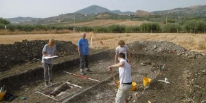
The term 'excavation' came from the Latin word excavare: ex- 'out' and cavare - 'to make or become hollow'. The dictionary definition of the act of excavating is one which digs, extracts, or removes materials from the ground in order to find remains. Excavation is the main tool of the archaeologist in learning about the past. Without it, only a small portion of the human past would be recovered and studied through history books (Champion 1980, 43), alternatively archaeology can examine the everyday lives of ordinary people. According to Barker it is "almost the only source of information... [that] provides evidence where the documents are silent or missing... [However] it is always destructive" (1993, 13).
The aim of an excavation is to "identify, define, uncover, date, and — by understanding transformation processes — interpret each archaeological context on a site" (Drewett 1999, 107). This is achieved by carefully recording what is in the ground, considering spatial organization and stratification which enables archaeologists to theorize the site purpose (King 2005, 71-72). The interpretive nature of the analysis of archaeological discoveries means different people have alternative ideas about the conclusions drawn after an excavation, this often stems back to the original purpose and aims of an excavation. There are three main reasons for conducting an archaeological excavation:
- salvage, or rescue archaeology: sites are excavated to save and record any information that will not be available in the future. Such sites are those that are vulnerable to natural erosion or urban developments, e.g. road systems, housing, dams etc. (Champion 1980, 43; Drewett 1999, 107; King 2005, 33 and 61; Renfrew and Bahn 2008, 75; Walker 2001).
- Research projects: Excavating to expand the knowledge of the past (King 2005, 28-29).
- Conservation: For purposes of cultural and heritage sites by interested organisations (King 2005, 87; Renfrew and Bahn 2008, 75).
Excavation, extracts everything that is known leaving little original evidence of the site (Barker 1986, 71). Barker argues further that the terrain containing the material remains plays a major part in human development (1993, 14), making the study of landscape a recent and growing sub discipline of archaeology (Renfrew and Bahn 2008, 77). Furthermore, in recent years archaeologists have considered how 'off-site' or 'non-site' areas may have also affected human development, especially where people are leading a mobile life leaving few remains, resulting in a sparse archaeological record which needs to be documented and carefully analysed rather than being excluded from the main excavation site (Renfrew and Bahn 2008, 77). However, exclusion is often the case as the "very faint scatters of artifacts... might not qualify as 'sites'... Nevertheless [they] represent significant human activity" (Renfrew and Bahn 2008, 77) and so should be recorded.
There are a number of writers and scholars who refer to excavation being destructive, but specific examples or case studies of such sites are seldom mentioned. Perhaps because the importance of the discoveries tends to outweigh the destruction caused by the excavation. The notion that the excavation process itself is a destructive one is self-explanatory (Barker 1986, 73-99); "Whether on a small or massive scale, [it] involves the destruction of the primary evidence, which can never be recovered nor repeated since no two sites are identical" (Champion 1980, 43). In response to this, if excavation is never undertaken with reference to the three main purposes of excavation above, then human knowledge of the past will never be expanded or included in our archives. King described sites as 'non-renewable resources' because they can never be returned to an undisturbed state after archaeological interference, he stresses the importance of an archaeologists appreciation of a site which they may be the last to study before it is destroyed (2005, 60-61). By this King could mean that archaeologists should recognise that excavation is disrupting the resting place of antiquities. So, when excavating, archaeologists should maximize their time to attain the greatest information they can in order to outweigh the destruction it can bring.
Although, there is not a single scholarly book based solely around the notion that excavation is non-destructive; non-destructive methods which may limit the need for excavation are frequently referred to. For instance, ground survey, with the help of technology, outlines the geological and geographical layout of the landscape, enabling archaeologists to have an idea of the site context in a wider landscape. Egyptologist Mark Lehner used Geographic Information Systems (GIS) in the Giza Plateau to expose the "vast urban centre attached to the pyramids, sometimes known as 'The Lost City of the Pyramid Builders'" (Renfrew and Bahn 2008, 92). The technology was also used to compile all the data they had, including digital photographs, notebooks, forms and artifact records into a single information source enabling them to map spatial patterns of architecture, burials and artifacts (Renfrew and Bahn 2008, 92).
The discovery of so called 'Japanese Atlantis' at Yonaguni proved to have shed light into the archaeological evidences of 'pyramids' and somehow brought legendary stories, which have been passed down through generations in the Ryukyu Islands, back to life (Journeyman Pictures 2008). Masaaki Kimura, a marine geologist from the University of Ryukyu, believes that a 5,000 year old city lies below the surface of the water at Yonaguni "based on dates of stalactites found inside underwater caves... ruins of a castle, a triumphal arch, five temples [and] one large stadium" (Ryall 2007). In this case, the knowledge attained from excavating the ruins at Yonaguni is immensely valuable, and the destruction caused by excavation was deemed appropriate due to the value and of the data obtained: an unknown city preserved by the water. Despite the excavation at Yonaguni being underwater, the processes involved are similar to ground excavations but, the scale and type of destruction may differ. For instance, "shifting vast quantities of sediment [and] removing bulky objects" from the ocean floor to the surface may mean that some materials are lost; the conservation of such artefacts which have survived in a waterlogged environment will also be very different (Renfrew and Bahn 2008, 109).
Methods such as 'non-destructive' or 'pre-excavation' techniques are increasing in popularity as alternatives to traditional excavations. These methods are often employed together as non-destructive methods are, in effect, pre-excavation techniques (Greene 2002, 50). Roskams stated that these techniques, either way you term them, are used "to give knowledge of sites prior to full excavation" (2001, 48). One such technique is reconnaissance survey from the air and the ground (Renfrew and Bahn 2008: 74, 79, 95, 99). This non-destructive technique began as a preliminary inquiry of an area of interest, but has developed into an important source of information in its own right, producing very different data to digging (Renfrew and Bahn 2008, 77).
Aerial reconnaissance is commonly known as 'aerial photography' and consists of different sub strategies which assist in locating and acquiring information from sites (Greene 2002, 62). For example, the use of oblique and vertical photographs have drawbacks and advantages that consequently affect the way interpreters and archaeologists decipher sites (Renfrew and Bahn 2008, 83). Other techniques used are analysing crop marks, soil marks and earth works in the landscape because they reveal where materials have been buried. For instance, crop marks can clearly exhibit where archaeological remains are since "buried features either enhance or reduce the growth of plants." (Greene 2002, 63-64; Roskams 2001, 44). These abnormalities can be detected using aerial photography and are used to assess sites in order to gain information or to help prepare for excavations, by indicating potential trench locations. In recent decades, technological advancements have also provided useful and valuable tools to improve the reliability of aerial photography. These include, infrared and radar photography, satellite images, digital terrain modelling, computer enhancement etc. (Renfrew and Bahn 2008, 86). Such additions can be used to critically reveal landscape and geological features and also improve the sharpness and contrasts of photos making differences in the crop easier to identify.
Aerial photography inevitably has pros and cons. The main advantage is that the identification of archaeological sites becomes easier and more time efficient as researchers do not have to rely on analysing ancient documents and maps to locate sites. For example, Father Antoine Poidebard in Syria has "discovered many new forts and roads [showing] that underwater sites could be detected from the air, revealing for the first time the ancient harbor beneath the sea at Tyre, Lebanon" (Renfrew and Bahn 2008, 79). According to Greene the use of aerial photography has "made the greatest single contribution to archaeological fieldwork and recording" (2002, 57) and is continuously used to map and document sites. Despite aerial photographs revealing the potential location of a site, most are far more complex than the impression given from how they look from the air (Barker 1986, 58). This means that excavation is still required if there is the need for further research. Aerial photography is a useful tool for locating, mapping, and documenting sites, however to gain a comprehensive interpretation of a site or in cases where further research is required, excavation is still the most useful method.
Likewise, ground reconnaissance is another key non-destructive method utilised regularly by archaeologists. The main advantage of using this method is that the whole landscape of the site can be mapped using three types of geophysical sensing: resistivity, magnetometry, and radar transmission (Greene 2002, 73; Roskams 2001, 52). When combining aerial and ground reconnaissance into a 3-D model, the results are immensely detailed; therefore the need to excavate can be carefully considered and questioned (Roskams 2001, 56).
In summary, excavation is said to be 'destructive' because of the process of removing remains from the ground, as stated by Barker (1986), Champion (1980) and King (2005). However, it is generally agreed that the scale of discovery and knowledge gained from the thorough excavation of a site outweighs the destruction it brings. With reference to examples mentioned, such as the Japanese Atlantis and the lost city of pyramid builders in the Giza Plateau, excavation expands our knowledge of the human past. It is the means to an end when it comes to further research on sites. 'Non-destructive' methods are known as 'pre-excavation' techniques because they are used to attain as much information as they can before resolving into excavation. Pre-excavation methods are especially useful when they combine aerial and ground survey techniques, as this can reliably indicate potential trench locations or possibly omit the need for excavation altogether.
Bibliography
- Barker, P. (1986). Understanding Archaeological Excavation. London: B. T. Batsford Limited.
- Barker, P. (1993). Techniques of Archaeological Excavation (third edition). London: B.T. Batsford Limited.
- Champion, S. (1980). A Dictionary of Terms and Techniques in Archaeology. London: Morisson and Bibb Ltd.
- Drewett, P. (1999). Field Archaeology: An introduction. London: UCL Press.
- Greene, K. (2002). Archaeology: An Introduction (fourth edition). London: Routledge.
- King, T. F. (2005). Doing Archaeology. A Cultural Resource Management Perspective. California: Left Coast Press.
- Renfrew, C. and Bahn, P. (2008). Archaeology: Theories, Methods and Practice (fifth edition). London: Thames and Hudson.
- Roskams, S. (2001). Excavation. Cambridge: University Press.
- Journeyman Pictures (2008) Japanese Atlantis. Available at: http://www.youtube.com/watch?v=zIu2rA0yd9s. Accessed on 11 April 2011.
- Ryall, J. (2007). Japan's Ancient Underwater "Pyramid" mystifies scholars. National Geographic News. Available at: http://news.nationalgeographic.com/news/2007/09/070919-sunken-city.html. Accessed on: 12 April 2011.
- Walker, M. (2001). Why excavate at all? NewArchaeology. Available at: http://www.newarchaeology.com/articles/whyexcavate.php. Accessed on: 11 April 2011.