"The Orkney Imagination is haunted by time" - (George Mackay Brown, cited Foster 2006, 57)
When you think of Orkney, you see images of an isolated community cut off from civilisation. The fact that Orkney is closer to Norway rather than London only verifies this for most people - I know this was the case for my family, who I have been convincing to take me there for the past few years. When they finally gave in this summer just past, I was excited to say the least. But what lay ahead? What actually were these desolate islands that I had roped my family into visiting for a fortnight? I realised that despite my longing to visit the Orkney Islands as a budding archaeologist, I knew nothing about them. My research and recent visit took me by surprise, changing my opinion and perspective of the islands for the better.
Orkney is actually inhabited by around 20,000 people, who occupy 21 out of approximately 67 islands that divide the Atlantic Ocean and the North Sea off the northern tip of Scotland (Wickham-Jones 2007, 1). The 'mainland' is now joined by a strip of man-made road to 5 other islands. This strip of land is called the 'Churchill Barriers' - a tarmac strip on building blocks simply placed into the sea. To the north of the mainland, there are a number of other islands — each with its own character. The smooth, rolling landscape of Orkney is formed mainly of sandstone which has been smoothed by glaciation. This gives the Islands a different atmosphere to Scotland, which is similar to the most southern of the Orkney Islands, Hoy; harsh, rugged with striking scenery. The views in Orkney are certainly still breathtaking, but it's the atmosphere created by the archaeology surrounding you, and the knowledge of what has taken place on the same spot for thousands of years that takes your breath away. The thought of standing in one of Orkney's many stone circles while witnessing the Northern Lights is surely enough to leave you blown away.
Any archaeologist will know that the Orkney Islands are rich in archaeology — both physically and materially. Humans have been on the islands for 10,000 years, and have dramatically shaped the landscape; wherever you look you see archaeology. The islands were first settled in the Mesolithic around 9,000 years ago (Wickham-Jones 2007, 13). Unfortunately, there is little evidence of this when touring the islands as no stone settlements remain. The only evidence of their existence on Orkney are numerous pieces of worked flint and shaped bone which is referenced to in guide books. Also, what were once lowlands in the Mesolithic are now underwater, which has changed the landscape severely over the past few thousand years. The landscape would have looked completely different; woodland would have featured near grassy open fields. Lagoons, bays and headlands would have been where the sea now is, altogether giving Orkney a contrasting look to the one I witnessed.
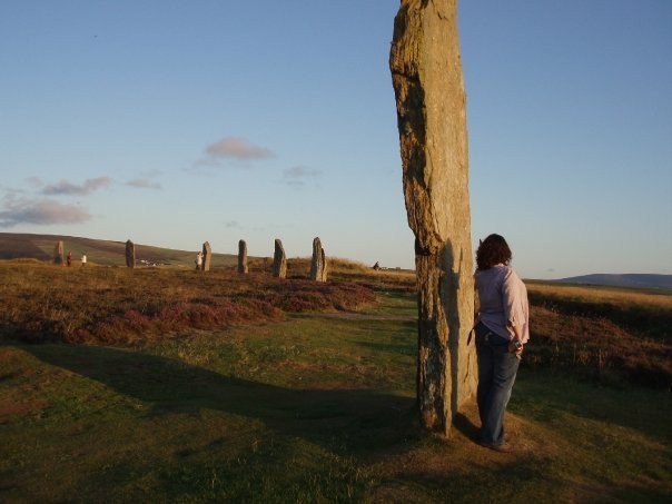
The lack of evidence stops there though, as the Neolithic sites in Orkney are numerous; there are over 90 sites, which for a small island is quite spectacular. The reason for this amount of evidence is the materials available to the people of the Neolithic. In Orkney there is more stone than woodland, unlike mainland Britain. This means that the Neolithic people used resources readily available; in their case, stone. This is good for tourists and archaeologists today as we can get a good idea of life in Neolithic Orkney. There are countless sites that you will encounter when visiting the islands, the 'Ring of Brodgar' being one already mentioned (Figure 1). The Ring of Brodgar is without doubt a mysterious monument, which was constructed approximately 4,500 years ago (Foster 2006, 34). The function of the henge is one much debated. There was obviously a ceremonial function, but was this just it? Did it extend to ritual or sacrifice, as some would have us believe? The location of the Ring of Brodgar is also special - it is sandwiched between two lochs, and is a world heritage site due to the amount of Neolithic sites in such close proximity:
- The Ring of Brookanl
- Brookan
- Ring of Brodgar (Figure 1)
- Ness of Brodgar
- Numerous amounts of standing stones
- Stones of Stenness
These are all within 2 miles of each other. This is obviously a significant site, and when there you automatically sense this. When visited at sunset the archaeology, in my opinion, looks its best (Figure 1). The dimming sunlight casts shadows on the earthworks, and also makes the stones more impressive due to the dusky glow of the evening.
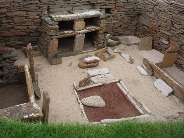
I was also taken aback by the condition of the remaining settlements of Neolithic Orkney. The infamous 'Skara Brae' (Figure 2) did not disappoint. The facilities and layout were equally fantastic for teaching and engaging the public. The museum explained about the site and the details of the discovery, and held artefacts found at the excavations. It paints a picture of Skara Brae's 'market place', industrial activities, and even talks about the leisure activities in the village (Clarke and Maguire 2007, 17 - 22).The site and museum explain more about Skara Brae then the archaeological text books seem to. It is clear when arriving at the site how much the landscape has changed; the bay was once fertile land for growing crops and grazing animals. This changed my view from people struggling to survive to an image of a civilized, complex society, who grew crops and lived in very close proximity to each-other for a number of years. It showed me that the skills these people had were not basic, and extinguished any doubt of an image of 'cave dwelling humans who grew corn' - For once in my life I was truly speechless. The house in figure 2 clearly shows two beds at either side of the house, a hearth in the centre, and a dresser/ sideboards to store and display objects. This was a house organised in a way which didn't change for thousands of years. This is apparent when looking at Iron Age Brochs, which are laid out in exactly the same way, but are slightly more advanced due to the use of metal.

The evidence of Iron Age occupation in Orkney is equally impressive; Brochs are scattered around the landscape. These Brochs were substantial occupational structures. The walls were hollow and roofed with timber (Wickham-Jones 2007, 82). The most visited of these on the mainland is the "Broch of Gurness". This example has a Broch with a surrounding village, complete with a main street leading from the village entrance to the Broch entrance, the village and houses ironically look similar to that of Skara Brae, despite being thousands of years apart. The community at Brochs such as Gurness were undoubtedly farmers, with cattle, sheep and pigs. The Iron Age community still hunted and fished though. After visiting the Broch of Gurness, it was obvious that the community was grouped into levels of society, with the 'highest' in the Broch, slowly moving out towards the edge of the village. What else was obvious when visiting, and then verified by Wickham-Jones (2007), is that the Iron Age settlers were involved in major warfare (2007, 85). This is evident due to the ditches and ramparts surrounding the settlement - it is obviously defensive rather than for show or decoration. The industry of the Iron Age is also apparent. The site of Mine Howe is a fantastic example of industrial activity. It is essentially a network of underground chambers dug into a large mound. The access is via a steep ladder, which goes down to the numerous chambers, branching out at right angles. Unlike sites in England, which would forbid entry to the mine, you are allowed to go inside. This does however, involve you dressing in a rather unattractive hard hat. It is well worth the money, looking a fool, and the steep climb, as the craftsmanship displayed in Mine Howe is amazing.
The other period of Orkney's history that jumps out at you is the Norse influence - It can be seen everywhere. The Norse arrived on the Islands and certainly left their mark. As with all places the Norse settled, or 'invaded', there are always suggestions of the infamous 'Viking raids'. While there is certainly evidence in Lindisfarne, Northumbria, according to Wickham Jones (2007, 111) the culprits of this could potentially be the northern isles of Britain, i.e. Orkney. But does this suggest a friendly relationship between the Norse invaders and the already settled Picts? This is a subject that has been long debated in archaeology. The evidence suggests a peaceful existence (Wickham-Jones 2007, 112). This is probably a generalisation, and the truth is most likely a combination of peace and warfare. As for the evidence of the Vikings in Orkney, the most striking is at Maeshowe. You may question this, considering that this a Neolithic site. You may also be asking me why this site was not mentioned while I was talking about the Neolithic period in Orkney. Well, the answer to this is simple, and can be explained by the image that I took away with me of Maeshowe. The Neolithic tomb of Maeshowe is located within a mile of the world heritage site where all the Neolithic sites mentioned earlier in this article are. The entrance to the tomb is aligned so that in midwinter, three weeks after the shortest day, the sun beams into the chamber, illuminating it with a spectacular glow. I however, was not fortunate enough to witness this, but instead went at sunset, on one of the guided tours. The first thing that struck me when I got to Maeshowe was the entrance, which was approximately 2 ft tall. The stone making the left wall was indeed a work of genius and incredible craftsmanship: incredibly it was one single stone. Inside the main chamber the walls were flag stones. There were side cells inside the main chamber and there were two upright standing stones directly in front of me, which bare striking resemblance to the henge, the Stones of Stenness. This was indeed a credit to Neolithic building technology. Even though this was a burial chamber, it was not what I noticed. While admiring the building work, I noticed runes on the wall. As part of the guided tour, we then heard of how the Norsemen broke into the mound in the 12th century. The runes in Maeshowe are the largest collection outside Scandinavia (Foster 2006, 20). The carvings are by the cook of Earl Rognvald. She tells of how they all travelled to Rome in 1153 after going on many adventures (Foster 2006, 20). There are many other doodles done by the Norsemen, including a competition above the doorway of who could write in the highest place; 'Eyjolf Kolbeinsson carved these runes high' (Foster 2006, 22).
This to me is why Maeshowe encompasses the classic image of Orkney. The thought of Norsemen taking refuge in a Neolithic burial mound, and leaving their mark for us to see on guided tours only adds to the intrigue of this Island. This sort of evidence would not be available in England, nor would it be so easy to look at in real life. This is what makes Orkney such a magical place — it is willing to give you a tantalising glimpse of its secrets, while keeping just enough locked away for you to speculate about it.
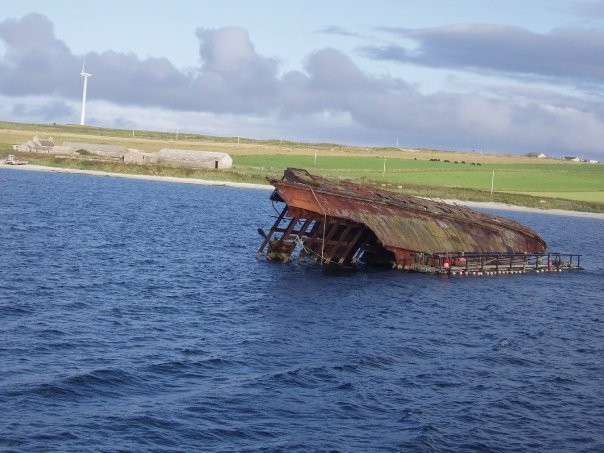
The archaeology does not stop there. There are echoes of the Second World War still visible on the islands. Orkney was a key player in the World wars due to the strategic importance of Scapa Flow, the stretch of water in the Orkney Islands. 100,000 people were sent to Orkney which improved roads, and provided an economic boom for farmers and merchants. It also created sites still visited today. The Italian chapel is actually a metal hut with a corrugated metal roof. The interior and exterior were decorated by Italian prisoners of war, and it is a truly beautiful space. As mentioned earlier in the article, the Churchill barriers link five of the islands to the mainland, and were built to 'create a safe anchorage for the British fleet within Scapa Flow' (Wickham-Jones 2007, 206). While driving over the Barriers, you will notice the remnants of ships sunk in the war. These have been left around the barriers and appear clearly out of the water, almost as a ship graveyard. It is sobering reminder of the war effort, and serves as part of a stunning view against the backdrop of the breathtaking Orkney landscape.
The Orkney Islands exceeded my families and my own expectations. The archaeology of this place changes your perspective on how the ancient people lived. These people were not simply surviving, but flourishing. The evidence at Skara Brae suggests a forward thinking community who led a fulfilling life. This is again suggested in the Iron Age site at the Broch of Gurness. The ceremonial sites are certainly more spectacular in the evening, and they are very well managed and very informative. Orkney is a fantastic place for a summer holiday as well as going there on digs. It is a relaxing place with a laid back way of life which affects you while you are there. I know I will certainly be returning for another instalment, and I advise any budding archaeologist to do the same.
Bibliography
- Foster, S. (2006) Maeshowe and the heart of Neolithic Orkney. Edinburgh: Historic Scotland.
- Wickham-Jones, J. (2007) Orkney: A Historical Guide. Edinburgh: Birlinn Limited.
- Clarke, D. and Maguire, P. (2007) Skara Brae: World Heritage Site. Edinburgh: Historic Scotland.